Leaflet.GeotagPhoto
Leaflet plugin for photo geotagging.
Examples:
Leaflet.GeotagPhoto is part of The New York Public Library’s NYC Space/Time Directory.
You can also find Leaflet.GeotagPhoto on Leaflet’s plugin page.
Usage
Include the following HTML in your page’s <head> tag:
<link rel="stylesheet" href="https://unpkg.com/leaflet-geotag-photo/dist/Leaflet.GeotagPhoto.css" />
<script src="https://unpkg.com/leaflet-geotag-photo/dist/Leaflet.GeotagPhoto.min.js"></script>
The HTML above links to the latest version of Leaflet.GeotagPhoto. In production, you should link to a specific version, to prevent newer versions breaking your application:
<link rel="stylesheet" href="https://unpkg.com/leaflet-geotag-photo@0.5.1/dist/Leaflet.GeotagPhoto.css" />
<script src="https://unpkg.com/leaflet-geotag-photo@0.5.1/dist/Leaflet.GeotagPhoto.min.js"></script>
Modes
L.GeotagPhoto.Crosshair
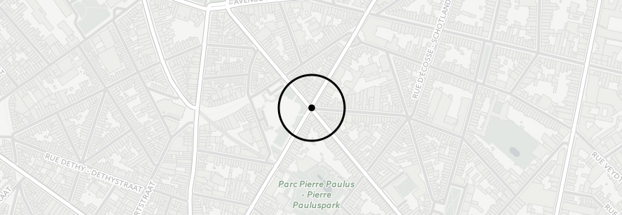
Example
L.geotagPhoto.crosshair().addTo(map)
  .on('input', function (event) {
    var point = this.getCrosshairPoint()
  })
API
L.GeotagPhoto.Crosshair extends L.Evented.
| Function | Description |
|---|---|
L.geotagPhoto.crosshair(options?) |
Creation |
addTo (map) |
Add L.GeotagPhoto.Crosshair to map |
removeFrom (map) |
Remove L.GeotagPhoto.Crosshair from map |
getCrosshairLatLng () |
Returns crosshair’s LatLng |
getCrosshairPoint () |
Returns crosshair’s GeoJSON Point |
Options
| Option | Type | Default | Description |
|---|---|---|---|
crosshairHTML |
HTML String |
<img src="<url>" width="100px" /> |
HTML string of crosshair element |
controlCrosshairImg |
url |
../images/crosshair.svg |
Crosshair image URL used by the default crosshairHTML |
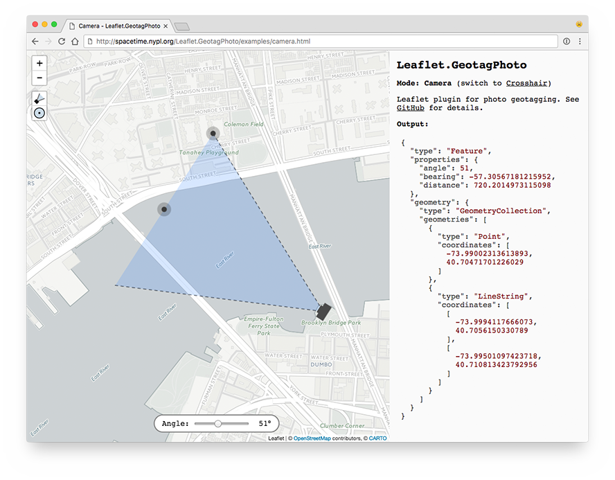
L.GeotagPhoto.Camera
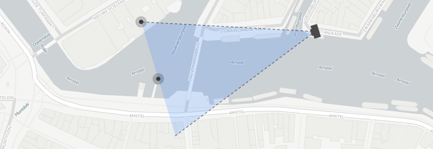
Example
var cameraPoint = [6.83442, 52.43369]
var targetPoint = [6.83342, 52.43469]

var points = {
  type: 'Feature',
  properties: {
    angle: 20
  },
  geometry: {
    type: 'GeometryCollection',
    geometries: [
      {
        type: 'Point',
        coordinates: cameraPoint
      },
      {
        type: 'Point',
        coordinates: targetPoint
      }
    ]
  }
}

var options = {
  draggable: true
}

L.geotagPhoto.camera(points, options).addTo(map)
  .on('change', function (event) {
    // Get camera field of view
    // See:
    //   https://github.com/nypl-spacetime/field-of-view#output
    var fieldOfView = this.getFieldOfView()
  })
API
L.GeotagPhoto.Camera extends L.FeatureGroup.
| Function | Description |
|---|---|
L.geotagPhoto.camera(feature, options?) |
Creation, feature is input for field-of-view |
getFieldOfView () |
Returns field of view of camera |
getCameraLatLng () |
Returns camera’s LatLng |
getTargetLatLng () |
Returns target’s LatLng |
getCameraPoint () |
Returns camera’s GeoJSON Point |
getTargetPoint () |
Returns target’s GeoJSON Point |
getCenter () |
Returns LatLng of point halfway camera and target |
getBounds () |
Returns LatLngBounds of field of view triangle |
centerBounds (bounds) |
Moves camera and target so their center lies in the middle of bounds |
setAngle (angle) |
Set angle of view |
setCameraLatLng (latLng) |
Set LatLng of camera |
setTargetLatLng (latLng) |
Set LatLng of target |
setCameraAndTargetLatLng (cameraLatLng, targetLatLng) |
Set LatLng of camera and LatLng of target |
setDraggable (boolean) |
Toggle between static or draggable camera |
Options
| Option | Type | Default | Description |
|---|---|---|---|
draggable |
Boolean |
true |
Whether the camera is draggable with mouse/touch or not |
angleMarker |
Boolean |
true |
Whether the angle of the field-of-view can be changed with a draggable marker |
minAngle |
Number |
5 | Minimum angle of field-of-view |
maxAngle |
Number |
120 | Maximum angle of field-of-view |
cameraIcon |
L.Icon |
See below | Camera icon |
targetIcon |
L.Icon |
See below | Target icon |
angleIcon |
L.Icon |
See below | Angle icon |
outlineStyle |
L.Path options |
See below | Style of field-of-view triangle’s outline |
fillStyle |
L.Path options |
See below | Style of field-of-view triangle’s fill polygon |
control |
Boolean |
true |
Whether to show camera control buttons |
controlCameraImg |
String |
../images/camera-icon.svg |
URL to icon displayed in camera control button |
controlCrosshairImg |
String |
../images/crosshair-icon.svg |
URL to icon displayed in crosshair control button |
Defaults
const defaults = {
  cameraIcon: L.icon({
    iconUrl: '../images/camera.svg',
    iconSize: [38, 38],
    iconAnchor: [19, 19]
  }),

  targetIcon: L.icon({
    iconUrl: '../images/marker.svg',
    iconSize: [32, 32],
    iconAnchor: [16, 16]
  }),

  angleIcon: L.icon({
    iconUrl: '../images/marker.svg',
    iconSize: [32, 32],
    iconAnchor: [16, 16]
  }),

  outlineStyle: {
    color: 'black',
    opacity: 0.5,
    weight: 2,
    dashArray: '5, 7',
    lineCap: 'round',
    lineJoin: 'round'
  },

  fillStyle: {
    weight: 0,
    fillOpacity: 0.2,
    fillColor: '#3388ff'
  }
}
Keyboard navigation
- Use
tabto switch between map, camera and target- Use arrow keys to move map, camera or target
- Press
Cto move camera to center of current map view - Press
Mto center map on current camera position
Building & Publishing
To build the plugin, run:
npm run build
The resulting files will be available in the dist directory.
To publish the plugin to npm and unpkg.com, run:
npm publish
See also
- http://spacetime.nypl.org/
- https://github.com/nypl-spacetime/field-of-view
- https://github.com/nypl-spacetime/surveyor
- http://turfjs.org/